World History
PERSEPOLIS AND ANCIENT IRAN. I found this website the other day and really enjoyed browsing it. As such, I thought I would blog about it today. It is a catalog of photographs of the ruins of the ancient capitol of the Persian Empire. It is presented by the Oriental Institute at the University of Chicago.
Persepolis and Ancient Iran was originally published as a text/microfiche publication by the University of Chicago Press in 1977. Now the whole collection can be browsed for free! I love the Web and how it can make content more available.
Here are a few images. These are copyrighted and my copy of just a few for non-profit purposes is allowed as fair use under American copyright law:
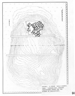
 ( Tall-i-Bakun. Contour Map, Showing the Prehistoric Mound and the Extent of the Excavations.)
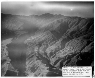
 ( Valley of Alamut, View of the "Valley of the Assassins", From an Altitude of 1,200 M on July 21, 1937.)
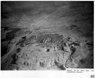
 (Susa, The Achaemenian Palaces.)
From the site:
The catalog is divided into four sections, summarizing the major areas of investigation: the architecture, reliefs, and finds of the Palaces at Persepolis; the prehistoric mound of Tall-i-Bakun; Istakhr, the Islamic city mound; and the aerial survey flights conducted between 1935 and 1937.
Each section describes the vast accumulation of artifacts uncovered and the buildings reconstructed out of the ruins of this ancient Persian capital. In addition, the expedition's aerial survey explorations are detailed, which constituted an important contribution to archaeological research techniques.
- Corinth Computer Project
The Corinth Computer Project - A computerized architectural and topographical survey of the Roman era colony of Corinth, by the University of Pennsylvania. It includes a city plan (circa 150 AD), a historical background, and a glossary. There is also...
- Theban Mapping Project
Theban Mapping Project. A continually evolving comprehensive archaeological database of the ancient Egyptian city of Thebes. Presents many useful site photos and diagrams. From the site: Since its inception in 1978, the Theban Mapping Project (TMP, now...
- Cahokia Mounds State Historic Site
Cahokia Mounds State Historic Site - Several mounds including Monks Mound, the largest earthen mound in the New World. This web site includes information on the interpretive center, and presents photos, history, and event calendar at this World Heritage...
- History Of Iran
History of Iran. This is an essay on the history of Iran which was known as Persia in ancient times. From the site: The ancient nation of Iran, historically known to the West as Persia and once a major empire in its own right, has been overrun frequently...
- How To Make A Mummy
The Getty Museum demonstrates how ancient Egyptians made mummies in the first short video below. In the second video, a museum associate offers more detail about their mummy and what it says about Egyptian society. You can read more about it here...
World History
PERSEPOLIS AND ANCIENT IRAN
PERSEPOLIS AND ANCIENT IRAN. I found this website the other day and really enjoyed browsing it. As such, I thought I would blog about it today. It is a catalog of photographs of the ruins of the ancient capitol of the Persian Empire. It is presented by the Oriental Institute at the University of Chicago.
Persepolis and Ancient Iran was originally published as a text/microfiche publication by the University of Chicago Press in 1977. Now the whole collection can be browsed for free! I love the Web and how it can make content more available.
Here are a few images. These are copyrighted and my copy of just a few for non-profit purposes is allowed as fair use under American copyright law:
 ( Tall-i-Bakun. Contour Map, Showing the Prehistoric Mound and the Extent of the Excavations.)
 ( Valley of Alamut, View of the "Valley of the Assassins", From an Altitude of 1,200 M on July 21, 1937.)
 (Susa, The Achaemenian Palaces.)
 From the site:
This document is a catalog of 999 photographs contained in an Oriental Institute text/microfiche publication entitled PERSEPOLIS AND ANCIENT IRAN. With an introduction by Ursula Schneider, former Oriental Institute photographer, it presents a comprehensive survey of archaeological sites in the environs of Persepolis.
The catalog is divided into four sections, summarizing the major areas of investigation: the architecture, reliefs, and finds of the Palaces at Persepolis; the prehistoric mound of Tall-i-Bakun; Istakhr, the Islamic city mound; and the aerial survey flights conducted between 1935 and 1937.
Each section describes the vast accumulation of artifacts uncovered and the buildings reconstructed out of the ruins of this ancient Persian capital. In addition, the expedition's aerial survey explorations are detailed, which constituted an important contribution to archaeological research techniques.
- Corinth Computer Project
The Corinth Computer Project - A computerized architectural and topographical survey of the Roman era colony of Corinth, by the University of Pennsylvania. It includes a city plan (circa 150 AD), a historical background, and a glossary. There is also...
- Theban Mapping Project
Theban Mapping Project. A continually evolving comprehensive archaeological database of the ancient Egyptian city of Thebes. Presents many useful site photos and diagrams. From the site: Since its inception in 1978, the Theban Mapping Project (TMP, now...
- Cahokia Mounds State Historic Site
Cahokia Mounds State Historic Site - Several mounds including Monks Mound, the largest earthen mound in the New World. This web site includes information on the interpretive center, and presents photos, history, and event calendar at this World Heritage...
- History Of Iran
History of Iran. This is an essay on the history of Iran which was known as Persia in ancient times. From the site: The ancient nation of Iran, historically known to the West as Persia and once a major empire in its own right, has been overrun frequently...
- How To Make A Mummy
The Getty Museum demonstrates how ancient Egyptians made mummies in the first short video below. In the second video, a museum associate offers more detail about their mummy and what it says about Egyptian society. You can read more about it here...
