World History
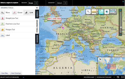 Tomorrow my students are looking at their connections to the world starting with the clothes on their backs. To that end I have been trolling the Internet for something that is interactive to show them. But in doing so I found this amazing world map which at the touch of a navigation button lets you see topographical, seas, satellite, National Geographic's map for a total of eight levels. But you can also get a tool to measure distances (across continents if you want) and draw with a pen or market all over the map. Once you are done with the map you can then download it. You can also mover your cursor anywhere and the longitude and latitude will pop up. In the lower part of the map, you can also see the entire world and the subset of what you are working on. You can also send someone a link of exactly what area of the map you are looking at, but I haven't figured out if you can save your work to that link. Here is the interactive site. If you figure out how to save your drawings on the map and have it on a url, please add it as a comment to this post.
So in the fall I may have my students use this to understand longitude and latitude as well as different types of maps.
- Scribble Maps
My students draw a lot of maps in Google Drawings, but if you want to do more than just labeling, you might want to consider Scribble Maps. Scribble maps allows you to put pins in locations, but then to add descriptions as well as Youtube video...
- My View On The Future Of Education
Last week the Alliance for Excellent Education (which is the inspiration behind Digital Learning Day) asked me to write a blog post for them. If you care to read the entire post go here where I have a number of links to items my students have done...
- Arcgis Mobile App - Free!!!
NO!!! Don?t skip over this because you have dealt in the past with a difficult to use ArcGIS product. This one really IS great!!! I do not claim expert knowledge on this app, but you can get up and running effectively with just a bit of experimentation....
- Data Dump
The US Census Bureau just released a whole slew of new data. This link will take you to the New York Times lesson plans site, where you can find a lesson and an interactive map showing the distribution of different racial and ethnic groups. ...
- Teaching About Buddhism?
This site from National Geographic is interactive, and shows some wonderful pictures of the giant Buddhas that are found near caves Dunhuang, China. Dunhuang was near the ancient Silk Roads. In the early 20th century, archaeologists made an...
World History
Interactive National Geographic Maps
So in the fall I may have my students use this to understand longitude and latitude as well as different types of maps.
- Scribble Maps
My students draw a lot of maps in Google Drawings, but if you want to do more than just labeling, you might want to consider Scribble Maps. Scribble maps allows you to put pins in locations, but then to add descriptions as well as Youtube video...
- My View On The Future Of Education
Last week the Alliance for Excellent Education (which is the inspiration behind Digital Learning Day) asked me to write a blog post for them. If you care to read the entire post go here where I have a number of links to items my students have done...
- Arcgis Mobile App - Free!!!
NO!!! Don?t skip over this because you have dealt in the past with a difficult to use ArcGIS product. This one really IS great!!! I do not claim expert knowledge on this app, but you can get up and running effectively with just a bit of experimentation....
- Data Dump
The US Census Bureau just released a whole slew of new data. This link will take you to the New York Times lesson plans site, where you can find a lesson and an interactive map showing the distribution of different racial and ethnic groups. ...
- Teaching About Buddhism?
This site from National Geographic is interactive, and shows some wonderful pictures of the giant Buddhas that are found near caves Dunhuang, China. Dunhuang was near the ancient Silk Roads. In the early 20th century, archaeologists made an...