World History
 Animated Maps
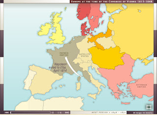
I stumbled upon this great resource today. Not only are the maps animated, but they are also narrated. There are a series of maps beginning with the Congress of Vienna. There are also some animated ancient maps. The best part is - they are FREE!
- Civil War Animated
I spent a pleasant hour today at a website titled Civil War Animated. The site depicts key land battles of the American Civil War using animation. The animation was colorful, was annotated, and left me a good sense of the history of each battle I examined....
- Maps Of World War Two
Maps of World War Two. A history of the Second World War through maps. Includes critical battles, and campaigns such as Dunkirk, Barbarossa, Stalingrad, Kursk, D-Day, Normandy, Berlin, and others. From the site: Maps of World War II provides an overview...
- Indian Ocean Trade
Studying Islam in India or Africa, then you are also probably studying trade in the Indian Ocean? This website offers one of the best resources I?ve seen on Indian Ocean trade. It?s an interactive site that has animated maps from each period in history...
- Great Depression In Europe/ Phenomenal Site
Studying the Great Depression in America and Europe? If so, you absolutely have to check out and explore this wonderful site that includes animated unemployment maps, short primary documents, photographs and cartoons from the period. Everything is very...
- Flat Maps
Flat Maps for the ClassroomI have to say "flat maps," since Google Maps are so great. But if you want to see traditional maps from every country in the world, you can go to Atlapedia. I found this site on Edgalaxy. ...
World History
History of Europe in the 19th Century - Animated Maps
Animated MapsI stumbled upon this great resource today. Not only are the maps animated, but they are also narrated. There are a series of maps beginning with the Congress of Vienna. There are also some animated ancient maps. The best part is - they are FREE!
This link (The Map As History) takes you to the actual website which has other helpful resources.
- Civil War Animated
I spent a pleasant hour today at a website titled Civil War Animated. The site depicts key land battles of the American Civil War using animation. The animation was colorful, was annotated, and left me a good sense of the history of each battle I examined....
- Maps Of World War Two
Maps of World War Two. A history of the Second World War through maps. Includes critical battles, and campaigns such as Dunkirk, Barbarossa, Stalingrad, Kursk, D-Day, Normandy, Berlin, and others. From the site: Maps of World War II provides an overview...
- Indian Ocean Trade
Studying Islam in India or Africa, then you are also probably studying trade in the Indian Ocean? This website offers one of the best resources I?ve seen on Indian Ocean trade. It?s an interactive site that has animated maps from each period in history...
- Great Depression In Europe/ Phenomenal Site
Studying the Great Depression in America and Europe? If so, you absolutely have to check out and explore this wonderful site that includes animated unemployment maps, short primary documents, photographs and cartoons from the period. Everything is very...
- Flat Maps
Flat Maps for the ClassroomI have to say "flat maps," since Google Maps are so great. But if you want to see traditional maps from every country in the world, you can go to Atlapedia. I found this site on Edgalaxy. ...