World History
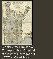 While browsing yesterday, I found a fun map site. The David Rumsey Map Collection focuses on 18th and 19th century North and South American cartographic materials. It includes maps, atlases, globes, school geographies, and maritime charts. This site is well worth a visit.
Some of the Rumsey Historical Maps are in Google Earth as well. Sixteen historical maps in the Featured Content layer of the Google Earth 3D Globe. The georeferenced maps wrap the virtual globe in their modern spaces, allowing explorations of both time and space.
From the site:
The David Rumsey Historical Map Collection has over 15,800 maps online. The collection focuses on rare 18th and 19th century North American and South American maps and other cartographic materials. Historic maps of the World, Europe, Asia, and Africa are also represented. Collection categories include antique atlas, globe, school geography, maritime chart, state, county, city, pocket, wall, childrens, and manuscript maps. Some examples are United States map, maps New York, California map, Arizona map, America map, New York City map, Chicago map, and Colorado map. The collection can be used to study history, genealogy and family history.
Read an article about the collection, take a Flash Tour of the collection (requires Flash), or view 360° panoramic images of the collection space. You can also view Japanese Historical Maps or fine art images from The AMICA Library.
- The Art Of African Exploration
The Art of African Exploration is a collection of 19th-century European paintings, drawings, and maps. It gives a good indication of how Africa as seen by Western eyes. This is yet another quality collection from the Smithsonian Institution Libraries....
- Historic Cities
I found a sharp site that features maps, literature, documents, books, and other materials concerning historic cities around the world. It is Historic Cities. It is a joint project of the Historic Cities Center of the Department of Geography, the Hebrew...
- Periodical Historical Atlas Of Europe
Periodical Historical Atlas of Europe - Maps showing political status of Europe and Mediterranean basin at the end of each century from AD 1 to AD 2000, plus maps of historical battle sites. Site is in both English and French....
- Maps Of World War Two
Maps of World War Two. A history of the Second World War through maps. Includes critical battles, and campaigns such as Dunkirk, Barbarossa, Stalingrad, Kursk, D-Day, Normandy, Berlin, and others. From the site: Maps of World War II provides an overview...
- American Powderhorns
American Powderhorns. A collection of antiques American powderhorns dating as far back as the French and Indian War. Also muskets, Kentucky Rifles and flintlock pistols. From the site: The powderhorn was the companion to every musket in early America....
World History
David Rumsey Map Collection
While browsing yesterday, I found a fun map site. The David Rumsey Map Collection focuses on 18th and 19th century North and South American cartographic materials. It includes maps, atlases, globes, school geographies, and maritime charts. This site is well worth a visit.Some of the Rumsey Historical Maps are in Google Earth as well. Sixteen historical maps in the Featured Content layer of the Google Earth 3D Globe. The georeferenced maps wrap the virtual globe in their modern spaces, allowing explorations of both time and space.
From the site:
The David Rumsey Historical Map Collection has over 15,800 maps online. The collection focuses on rare 18th and 19th century North American and South American maps and other cartographic materials. Historic maps of the World, Europe, Asia, and Africa are also represented. Collection categories include antique atlas, globe, school geography, maritime chart, state, county, city, pocket, wall, childrens, and manuscript maps. Some examples are United States map, maps New York, California map, Arizona map, America map, New York City map, Chicago map, and Colorado map. The collection can be used to study history, genealogy and family history.
Read an article about the collection, take a Flash Tour of the collection (requires Flash), or view 360° panoramic images of the collection space. You can also view Japanese Historical Maps or fine art images from The AMICA Library.
- The Art Of African Exploration
The Art of African Exploration is a collection of 19th-century European paintings, drawings, and maps. It gives a good indication of how Africa as seen by Western eyes. This is yet another quality collection from the Smithsonian Institution Libraries....
- Historic Cities
I found a sharp site that features maps, literature, documents, books, and other materials concerning historic cities around the world. It is Historic Cities. It is a joint project of the Historic Cities Center of the Department of Geography, the Hebrew...
- Periodical Historical Atlas Of Europe
Periodical Historical Atlas of Europe - Maps showing political status of Europe and Mediterranean basin at the end of each century from AD 1 to AD 2000, plus maps of historical battle sites. Site is in both English and French....
- Maps Of World War Two
Maps of World War Two. A history of the Second World War through maps. Includes critical battles, and campaigns such as Dunkirk, Barbarossa, Stalingrad, Kursk, D-Day, Normandy, Berlin, and others. From the site: Maps of World War II provides an overview...
- American Powderhorns
American Powderhorns. A collection of antiques American powderhorns dating as far back as the French and Indian War. Also muskets, Kentucky Rifles and flintlock pistols. From the site: The powderhorn was the companion to every musket in early America....